File=>More File Functions=>Load 3D Data Hull
Loads a data hull from an ASCII or Excel file into a selected 3D dataset.
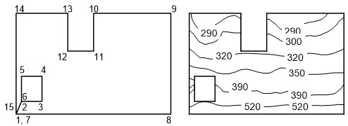
Only isolines within the data hull of the contour map will be plotted. Only the surface facets of the 3D Plot that lie completely inside the hull will be plotted.
The data hull must be a three column ASCII, Text or Excel file. The first and the second column contain the x- and y- coordinates and the third column contains a control letter. The control letter determines which points should be connected by lines.
The following 4 letters can be used as control letters:
m is the short form of Move To. The letter can be used to reach islands without inserting a connecting line.
M has the same meaning as m, but the point will be labeled by the z-value of the contour map at this position.
l is short form for Line To. This letter ensures that a visible line is drawn.
L has the same meaning as l, but the point will be labeled by the z-value of the contour map at this position.
The following is the plotted hull’s ASCII file. The numbers in brackets relate to the numbering system in the illustration. They are not allowed to be entered into the hull file.
1500    20  m   (1)
1600    30  m   (2)
2000    30  l   (3)
2000    50  l   (4)
1600    50  l   (5)
1600    30  l   (6)
1500    20  m   (7)
4500    20  l   (8)
4500    100 l   (9)
3000    100 l   (10)
3000    70  l   (11)
2500    70  l   (12)
2500    100 l   (13)
1500    100 l   (14)
1500    20  l   (15)
Comment
The functions in this dialog box are written in UniScript. The source code can be
found in the file do_file.ic.
See also
id-776495